ARCdoc retracing the first leg of a 19th century Arctic whaling voyage
ARCdoc will once again be taking to the seas, this time in the interests of education. In partnership with the Ocean Youth Trust North (OYTN) and Burnside Business & Enterprise College (based in North Shields) we will be retracing the first leg of a 19th century Arctic whaling voyage.
All of the whaling logbooks being used by ARCdoc originate from ships sailing from the UK’s east coast. Between 1750 – 1850 all east coast ports were involved with the whaling trade in some capacity. These east coast whalers would sail north to the Orkney or Shetland Islands, where they would embark the majority of their crew before heading to the Arctic whaling grounds. It is this first leg, from Newcastle to Kirkwall, Orkney that we will be recreating in a few days time!
Matthew, ARCdoc’s research student will be joining 10 students and 2 teachers from Burnside School on board the OYTN’s vessel, the ‘James Cook’, a 70ft, 54 tonne steel hulled ketch. The OYTN is a charity specialising in the personal development of young people and adults through the medium of ocean sailing.
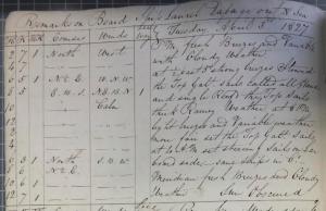
On board the students will be keeping a replica 19th century logbook, just like the ones used in ARCdoc’s research. Using the nautical day, starting at noon, they will be keeping 2 hourly observations of the course and speed of the ship, wind direction, wind force and prevailing weather conditions. Wind and weather observations will be conducted using non-instrumental observations and speed will be calculated using a replica chip log.
Log extract from the Hull whaler ‘Laurel’ 1827
The chip log was the original device used to measure a ship’s speed, and dates back to the 15th century. The end of the log was lowered into the water, then the line was allowed to play out for 30 seconds after which the line was pulled in and the number of knots counted. Older chip logs had knots tied at every 42 feet, each knot representing 1 nautical mile an hour (or knot as it is now known). Later refinements in the distance of a nautical mile caused the knots to be tied slightly further apart at 47 feet 3 inches. It is this corrected unit of measure that is used on the chip log we will be using.
The chip log the students will be using to measure the speed of the James Cook.
Using these observations the students will be trying their hand at simple dead reckoning navigation and comparing their observations against the electronic navigational equipment (GPS) on board. It will be interesting to get a sense of the accumulated errors associated with dead reckoning.
We hope this adventure will provide the students with a real sense of their cultural history. As with many historic ports, some of the students could well be distant relatives of old Arctic whalers. We also hope they will gain an understanding of ARCdoc’s research, the sources we use and how they can be used to understand past climates.
You can follow our voyage via the OYTN’s website: http://www.sailjamescook.com/about/james-cook/follow-james-cook
We will be departing the Tyne on Saturday 20th July.

